Important Bird Area Sites in Massachusetts
Important Bird Area: Kalmus Beach Park
Site Summary
Nominated By
Matt Bailey, Scott Hecker
Size
17 acres
Towns and Counties
Barnstable
Ownership
Municipal
Major Habitats
90% coastal beach, 10% marine/tidal, migratory stopover site
Land Use
hunting/fishing, other recreation or tourism, dredge deposit site
Serious Threats
invasive plants, succession, predators, habitat conversion, disturbance to birds
Minor Threats
recreational overuse, fireworks, introduced animals or feral pets
IBA Criteria
- Category 1: Seabirds: The site regularly supports 300 or more pelagic seabirds and/or terns or 3,000 or more gulls at one time. A pelagic site is the actual location being used by seabirds (e.g., Stellwagen Bank) and not the location from which an observer counts seabirds (e.g., Provincetown). Smaller concentrations of less common gulls such as Laughing or Bonaparte's gullswill be considered. Human-made food sources for gulls such as landfills and sewage outflows will not be considered. The designation "seabirds" includes shearwaters, storm-petrels, fulmars, gannets, jaegers, and alcids.
Site Description
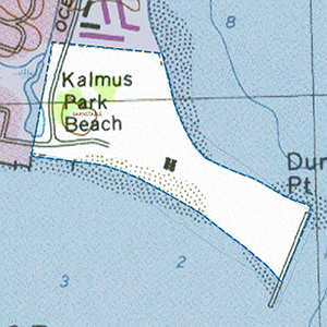
Kalmus Park is a coastal barrier beach peninsula and public bathing beach owned by the town of Barnstable. On topographic maps it is referred to as Dunbar Point, and the park separates Lewis Bay from Nantucket Sound. Formerly, it was a natural barrier beach dominated by beach grass, but was later armored with a very long jetty at its tip that runs from the back of the beach out past the front into Nantucket Sound. Since 1985 the site has been used as an area to deposit dredged sand from a nearby channel on two occasions. The first deposit occurred in 1985 along 200 yards of beach on the slope facing Nantucket Sound, which expanded the beach outward onto the tidal flat and renourished approximately 2 acres of beach. During the winter of 1997-98, a much larger dredging and beach renourishment project buried 75% of the peninsula, including all vegetation, in dredged sand and shell to an added height of 15 feet or more.
Current Conservation Status
The adjoining parking lot supports heavy site use during the summer by beachgoers and windsurfers. This site will likely continue to be used as a disposal site for sand dredged from the channel, which will create habitat for beach-nesting birds
Ornithological Significance
In 1986, a dredged deposit of sand and shell not subsequently planted with beach grass attracted a high of 402 pairs of Least Terns and 2 pairs of Piping Plovers. Over the next 10 years, as vegetation became reestablished, the site declined in importance for tern nesting. However, in 1998 a much larger dredging project was completed and covered over 10 acres of beach with unplanted, dredged sand. By the summer of 1999, the site attracted the largest Least Tern colony on record in Massachusetts with approximately 1,420 pairs of Least Terns (42% of the state population) while Piping Plovers increased to 5 to 7 pairs in recent years. However, by 2002, the colony diminished to only a few hundred pairs of terns that later abandoned the site, probably resulting from predation. Every spring significant flocks of Roseate Terns use Kalmus Park Beach as a staging area prior to settling in to their breeding sites.
Other Flora or Fauna of Significance
None described.
Data Sources
None provided.


