Breeding Bird Atlases (BBA)
Find a Bird
Swamp Sparrow
Melospiza georgiana

Widespread and likely increasing
“The Swamp Sparrow is not a public character. He will never be popular or notorious. He is too retiring to be much in the public eye, and too fond of the impassable bog and morass to have much human company; and so he comes and goes unheralded and to most people unknown.” – Edward Howe Forbush, Birds of Massachusetts and Other New England States
The impassable bog and morass may be a poor place to entertain human company, but a densely overgrown wetland is very inviting to a Swamp Sparrow. Its slow, repeated trill is a common accompaniment to practically any slog through one of the Bay State’s marvelous marshes. Humankind’s destructive relationship with swampland and marshland may have been detrimental to Swamp Sparrows in the past, but the species’ recovery is showing promise for the future.
Historic Status
As wetlands go, so, it is likely, goes the Swamp Sparrow. No historical data exists to reflect the birds’ relationship to European settlement in Massachusetts, but what once was a landscape of free-flowing brooks and streams interrupted by beaver dams was quickly changed to one of millponds, farms, and villages — a transition that likely altered the breeding distribution of this species. Farmers “reclaiming” wetlands caused further changes, and the twentieth-century practice of filling wetlands for suburban development no doubt also created challenges for this species. As William Brewster noted, the presence of breeding Swamp Sparrows followed available habitat closely: “…one or two pairs nested every season in a little meadow just to the westward of the Cambridge reservoir on Highland Street, and others on a floating island in the pond at the rear of Mount Auburn. The Swamp Sparrows have long since disappeared from these localities, but in the Fresh Pond Swamps and at Rock Meadow they continue to appear as numerously as they have ever done within the period covered by my recollection” (Brewster 1906).
Atlas 1 Distribution
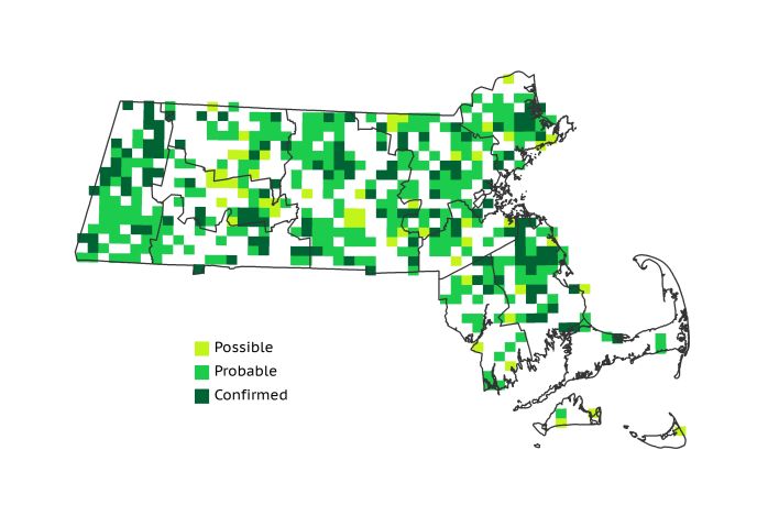
Swamp Sparrows were widespread in Atlas 1, and were found in 47% of the blocks surveyed. Their patterns of regional occupancy vary greatly. The higher ecoregions in the western part of the state had scattered Swamp Sparrow records, but percentages of occupied blocks were increased in the lower elevation areas. The Marble Valleys, Connecticut River Valley, and even the Lower Berkshire Hills all had 50% or better rates of block occupancy. The Worcester and Lower Worcester Plateaus each had strong showings from the Swamp Sparrow, as did the Coastal Plains. The Bristol/Narragansett Lowlands had less robust figures (44% occupancy), and the entire Cape and Islands had only 18 blocks, likely a function of that region’s dry, sandy soil and largely saline rather than freshwater marshes.
Atlas 2 Distribution and Change
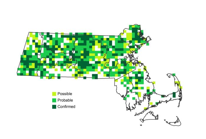
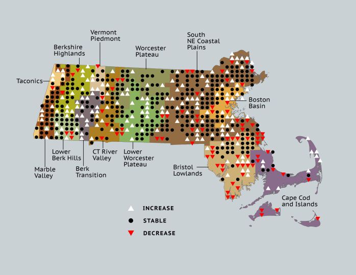
In general, Swamp Sparrows expanded their range in Massachusetts, increasing their footprint in all ecoregions except the Bristol/Narragansett Lowlands, and overall increasing to 59% block occupancy. There are scattered losses in other parts of the state, but the net loss in the Bristol/Narragansett Lowlands is notable. Swamp Sparrows remained stable on Cape Cod and the Islands, not showing a net loss or gain in occupied blocks, but abandoned Nantucket and Martha’s Vineyard while at the same time reaching farther east onto the extended arm of the Outer Cape.
Atlas 1 Map

Atlas 2 Map

Atlas Change Map

Ecoregion Data
Atlas 1 | Atlas 2 | Change | ||||||
Ecoregion | # Blocks | % Blocks | % of Range | # Blocks | % Blocks | % of Range | Change in # Blocks | Change in % Blocks |
Taconic Mountains | 6 | 37.5 | 1.3 | 8 | 32.0 | 1.3 | 2 | 13.3 |
Marble Valleys/Housatonic Valley | 29 | 74.4 | 6.4 | 35 | 89.7 | 5.7 | 6 | 15.4 |
Berkshire Highlands | 22 | 40.0 | 4.8 | 36 | 65.5 | 5.9 | 12 | 22.6 |
Lower Berkshire Hills | 21 | 75.0 | 4.6 | 26 | 83.9 | 4.3 | 3 | 11.1 |
Vermont Piedmont | 7 | 41.2 | 1.5 | 14 | 82.4 | 2.3 | 2 | 16.7 |
Berkshire Transition | 14 | 36.8 | 3.1 | 33 | 82.5 | 5.4 | 14 | 45.2 |
Connecticut River Valley | 28 | 50.0 | 6.2 | 35 | 53.8 | 5.7 | 3 | 6.3 |
Worcester Plateau | 47 | 60.3 | 10.3 | 78 | 88.6 | 12.8 | 10 | 20.8 |
Lower Worcester Plateau | 41 | 55.4 | 9.0 | 63 | 78.8 | 10.3 | 9 | 16.7 |
S. New England Coastal Plains and Hills | 155 | 57.4 | 34.1 | 196 | 69.3 | 32.2 | 20 | 8.8 |
Boston Basin | 20 | 35.7 | 4.4 | 29 | 51.8 | 4.8 | 9 | 16.4 |
Bristol and Narragansett Lowlands | 47 | 44.3 | 10.3 | 37 | 32.5 | 6.1 | -10 | -9.9 |
Cape Cod and Islands | 18 | 13.2 | 4.0 | 19 | 13.2 | 3.1 | 0 | 0.0 |
Statewide Total | 455 | 47.0 | 100.0 | 609 | 58.7 | 100.0 | 80 | 9.7 |
Notes
Despite this apparent stability, the Breeding Bird Survey shows significant declines in the Swamp Sparrow’s abundance for the New England/Mid-Atlantic Region.


