Find a Bird
Common Loon
Gavia immer

Local and strongly increasing
Species of Special Concern

“I have a song to sing, O! / Sing me your song, O! / It is sung to the moon by a love-lorn loon / Who fled from the mocking throng, O!” – Gilbert and Sullivan, The Yeomen of the Guard
Perhaps no sound is as emblematic of the northern wilderness as the haunting tremolo cry of the Common Loon. Ideal breeding habitat for Common Loons consists of large, clear, healthy lakes or ponds with abundant fish and a good amount of cover along the shorelines. Draining of wetlands and development along waterfronts has deprived loons of the habitat they need to continue breeding in Massachusetts. As shooting culled their numbers and development reduced the amount of undisturbed habitat, the loons left. Probably by 1900, the breeding of Common Loons in Massachusetts was a thing of the past, even though parts of northern New England were apparently able to sustain a modest, if not diminished, population of Common Loons despite extensive shooting and collection of their eggs. It was not until suitable habitat (i.e., the creation of Quabbin Reservoir) became available in Massachusetts that Common Loons returned to the Bay State as breeders.
Historic Status
Prior to the beginning of the twentieth century, Common Loon breeding records in Massachusetts were mostly singular accounts: e.g., Billington Sea in Plymouth, Lakeville (1872), and in ponds around Winchendon. Alexander Wilson and Thomas Brewer stated that although they had never personally seen loons breeding in Massachusetts, “it is said they do in Missibisci Pond, near Boston,” but, unfortunately, the modern name of that pond has yet to be discovered (Wilson & Bonaparte 1831). Yet, as unpalatable as they were to eat, loons were hunted heavily in the state, including during the critical spring breeding season. By 1925, Edward Howe Forbush declared that Common Loons were “shot out at a great expenditure of powder and lead or driven out by continual persecution. They died hard; but they are gone, perhaps never to return” (Forbush 1925).
Atlas 1 Distribution
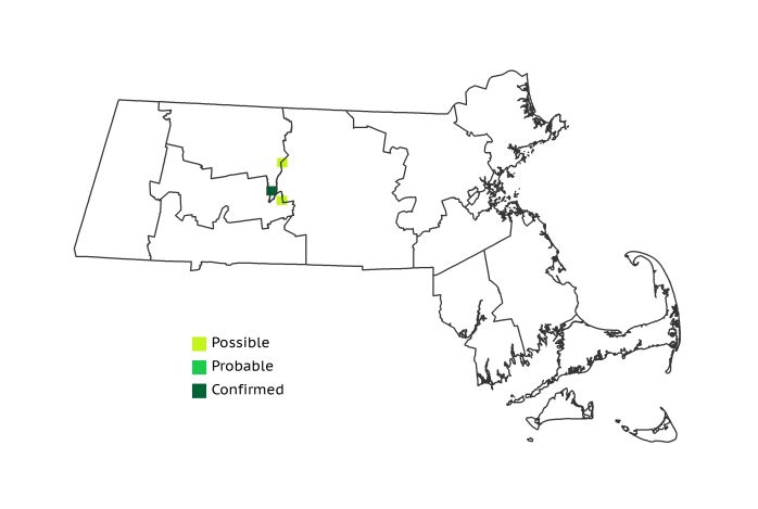
Its status as an icon of northern wilderness was evidently not enough to insulate the Common Loon against the depredations of man, although a few hardy pairs were able to conquer the odds and breed in Massachusetts by the time of Atlas 1. Three occupied blocks along the divide between the Worcester Plateau and the Lower Worcester Plateau mark the surest example of suitable loon habitat in all of Massachusetts – Quabbin Reservoir. This artificial expanse of open water, created in the 1930s, and stringently monitored and protected as befits a source of potable water, was the foothold that Common Loons required to begin reestablishing themselves in the Commonwealth.
Atlas 2 Distribution and Change
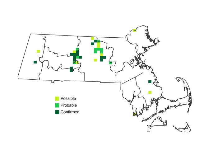
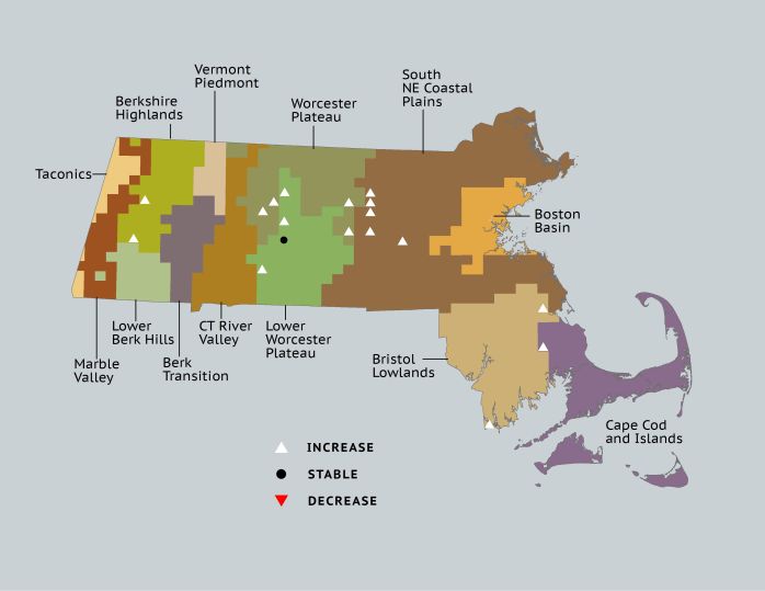
The Quabbin Reservoir, which was a Depression-era project and therefore just beyond the years of Forbush, went from foothold to Massachusetts stronghold for nesting Common Loons by Atlas 2. The species spread, if sparingly, into the Worcester Plateau and the Southern New England Coastal Plains, with outliers occupying a handful of blocks in the Berkshire Highlands and the Bristol/Narragansett Lowlands. In all, the species went from breeding in less than 1% of the blocks to slightly more than 3%, but these gains were nonetheless noteworthy. The Confirmed record in Plymouth County is an error, and should be listed as a Possible breeding record.
Atlas 1 Map

Atlas 2 Map

Atlas Change Map

Ecoregion Data
Atlas 1 | Atlas 2 | Change | ||||||
Ecoregion | # Blocks | % Blocks | % of Range | # Blocks | % Blocks | % of Range | Change in # Blocks | Change in % Blocks |
Taconic Mountains | 0 | 0.0 | 0.0 | 0 | 0.0 | 0.0 | 0 | 0.0 |
Marble Valleys/Housatonic Valley | 0 | 0.0 | 0.0 | 0 | 0.0 | 0.0 | 0 | 0.0 |
Berkshire Highlands | 0 | 0.0 | 0.0 | 2 | 3.6 | 5.4 | 2 | 3.8 |
Lower Berkshire Hills | 0 | 0.0 | 0.0 | 0 | 0.0 | 0.0 | 0 | 0.0 |
Vermont Piedmont | 0 | 0.0 | 0.0 | 0 | 0.0 | 0.0 | 0 | 0.0 |
Berkshire Transition | 0 | 0.0 | 0.0 | 0 | 0.0 | 0.0 | 0 | 0.0 |
Connecticut River Valley | 0 | 0.0 | 0.0 | 0 | 0.0 | 0.0 | 0 | 0.0 |
Worcester Plateau | 1 | 1.3 | 33.3 | 14 | 15.9 | 37.8 | 4 | 8.3 |
Lower Worcester Plateau | 2 | 2.7 | 66.7 | 9 | 11.3 | 24.3 | 3 | 5.6 |
S. New England Coastal Plains and Hills | 0 | 0.0 | 0.0 | 9 | 3.2 | 24.3 | 5 | 2.2 |
Boston Basin | 0 | 0.0 | 0.0 | 0 | 0.0 | 0.0 | 0 | 0.0 |
Bristol and Narragansett Lowlands | 0 | 0.0 | 0.0 | 2 | 1.8 | 5.4 | 2 | 2.0 |
Cape Cod and Islands | 0 | 0.0 | 0.0 | 1 | 0.7 | 2.7 | 1 | 0.8 |
Statewide Total | 3 | 0.3 | 100.0 | 37 | 3.6 | 100.0 | 17 | 2.1 |


