Find a Bird
Northern Waterthrush
Parkesia noveboracensis
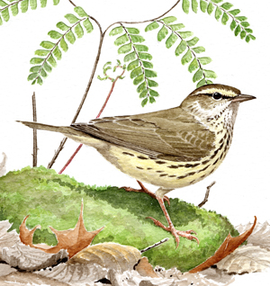
Fairly widespread and strongly increasing
“Its nest I have never seen, though I’ve spent many midsummer afternoons, mosquito-tortured, in its nesting places, watching it trip about among black puddles, and hearing its vivid sudden song.” – Frank W. Chapman, The Warblers of North America
Although Northern Waterthrushes are quite reclusive, they are loud and strong singers. These birds walk like thrushes and bob their tails like Spotted Sandpipers, but like the Ovenbird they are members of the wood-warbler clan. It and its cousin the Louisiana Waterthrush have recently been moved to their own genus, Parkesia, in recognition of their unique genetic history, a history that is obvious to glean when the lucky birder chances to watch them in action. Northern Waterthrushes favor the edges of still waters such as swamps, ponds, and sluggish brooks for foraging and nest building, indeed ideal places if one is looking to be mosquito-tortured.
Historic Status
The debate was wide open as to whether or not the Northern Waterthrush, or “Water Wagtail” as it was called at that time, bred in Massachusetts during the 1800s. More than one ornithologist claimed that it did without having certifiable evidence, but there were skeptics prepared to challenge such a claim (Howe & Allen 1901). In 1929, Edward Howe Forbush wrote, “In summer pairs are scattered sparingly over the northern and western parts of the state, but because of their scarcity at this season, their shyness and the care with which they conceal their nests, records of actual breeding within our limits are rather rare,” (Forbush 1929).
Atlas 1 Distribution
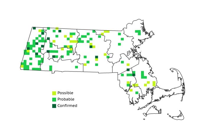
During Atlas 1 Northern Waterthrushes were present in small numbers in every region except the Boston Basin, but their thin distribution posted only 14% occupied blocks statewide. The western regions, particularly the Marble Valleys, accounted for the lion’s share of the bird’s breeding distribution in Massachusetts, and the regions west of the Connecticut River Valley hosted 47% of the species’ range. Wooded swamps and bogs certainly played host to waterthrushes in the Berkshire Transition and Vermont Piedmont, but the more agrarian character of the Connecticut River Valley precluded much breeding activity in that region. The Worcester Plateau, another hot spot, had 19 blocks with breeding evidence, though breeding activity in the more eastern regions was highly local. The Bristol/Narragansett Lowlands had several pockets of breeding Northern Waterthrushes, presumably in areas of White Cedar swamps, but on Cape Cod the species was virtually absent except as a Possible breeder at the very base of the region.
Atlas 2 Distribution and Change
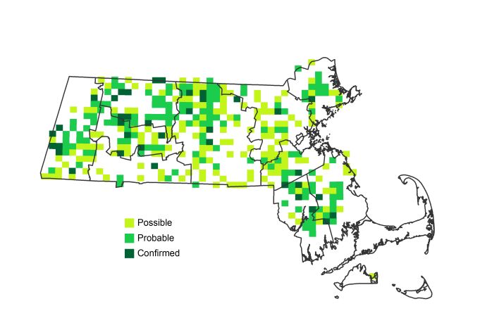
Seemingly in many places where slow or standing water was available in a mature woodland setting with heavy undergrowth, the Northern Waterthrush showed signs of expanding to make use of it during Atlas 2, and its statewide footprint grew to 34%. Aside from its puzzling disappearance from a dozen blocks in the Marble Valleys, and a decline in the Taconics, this species was generally stable or increasing in the western highlands. The Worcester Plateau regions both had the Northern Waterthrush expand into 19 new blocks, and the colonization of 80 blocks in the Coastal Plains represented a major eastward push for the species. The heart of the Bristol/Narragansett Lowlands also saw marked expansion, though Cape Cod and the Islands remained mostly devoid of this species.
Atlas 1 Map
Atlas 2 Map
Atlas Change Map
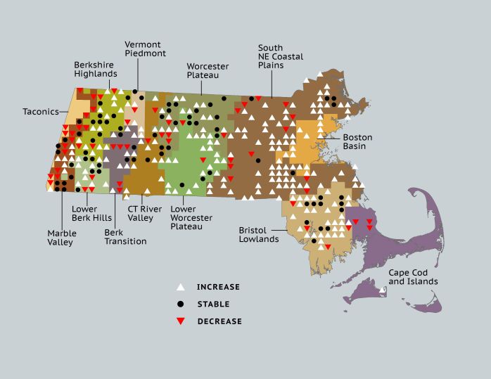
Ecoregion Data
Atlas 1 | Atlas 2 | Change | ||||||
Ecoregion | # Blocks | % Blocks | % of Range | # Blocks | % Blocks | % of Range | Change in # Blocks | Change in % Blocks |
Taconic Mountains | 4 | 25.0 | 3.0 | 1 | 4.0 | 0.3 | -3 | -20.0 |
Marble Valleys/Housatonic Valley | 22 | 56.4 | 16.4 | 17 | 43.6 | 4.8 | -5 | -12.8 |
Berkshire Highlands | 16 | 29.1 | 11.9 | 30 | 54.5 | 8.5 | 12 | 22.6 |
Lower Berkshire Hills | 9 | 32.1 | 6.7 | 14 | 45.2 | 4.0 | 5 | 18.5 |
Vermont Piedmont | 4 | 23.5 | 3.0 | 7 | 41.2 | 2.0 | 2 | 16.7 |
Berkshire Transition | 8 | 21.1 | 6.0 | 17 | 42.5 | 4.8 | 5 | 16.1 |
Connecticut River Valley | 7 | 12.5 | 5.2 | 21 | 32.3 | 6.0 | 7 | 14.6 |
Worcester Plateau | 19 | 24.4 | 14.2 | 58 | 65.9 | 16.5 | 14 | 29.2 |
Lower Worcester Plateau | 8 | 10.8 | 6.0 | 35 | 43.8 | 9.9 | 17 | 31.5 |
S. New England Coastal Plains and Hills | 18 | 6.7 | 13.4 | 98 | 34.6 | 27.8 | 68 | 30.1 |
Boston Basin | 0 | 0.0 | 0.0 | 11 | 19.6 | 3.1 | 11 | 20.0 |
Bristol and Narragansett Lowlands | 15 | 14.2 | 11.2 | 40 | 35.1 | 11.4 | 24 | 23.8 |
Cape Cod and Islands | 4 | 2.9 | 3.0 | 3 | 2.1 | 0.9 | -1 | -0.8 |
Statewide Total | 134 | 13.8 | 100.0 | 352 | 33.9 | 100.0 | 156 | 18.8 |


