Find a Bird
Golden-winged Warbler
Vermivora chrysoptera
Very local and strongly declining
Conservation action urgent
Endangered Species
"He loves to sit and hear me sing, / Then, laughing, sports and plays with me; / Then stretches out my golden wing, / And mocks my loss of liberty.” – William Blake, “How sweet I roam’d from field to field”
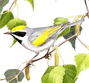
The Golden-winged Warbler has much in common with the closely related Blue-winged Warbler. Although some isolation of their populations must have occurred to allow differentiation in the past, the range of these two species is overlapping more and more with each passing year. Thus, these so-called “kissing cousins” are interbreeding freely, producing fertile hybrid offspring that in turn are mating both with each other and with their parent species. Wherever the Blue-winged Warbler is increasing, it is usually at the expense of the Golden-winged Warbler.
Historic Status
The Golden-winged Warbler is a species that was unknown as a breeder in Massachusetts prior to the widespread clearing of land for agriculture following the early colonization of the region. In fact, the Golden-winged Warbler was unknown as a breeder in Massachusetts until many farms were abandoned and the landscape began to revert to early second growth. James Elliot Cabot shot a Golden-winged Warbler in Cambridge sometime in the 1830s, and that was enough for William Peabody to consider the species countable on the Massachusetts list when he made his report to the state legislature (Peabody 1839). Charles Johnson Maynard found the first recorded Massachusetts nest in West Newton on June 12, 1869, noting that a “Cow Bunting” (Brown-headed Cowbird) had also left an egg in the same nest (Maynard c1870). The Golden-winged Warbler never really thrived in Massachusetts in large numbers, but it took advantage of early-successional habitat wherever it could. With the gradual disappearance of early-successional habitat in the face of forest regeneration, the species gradually began to decline in the mid- to late twentieth century.
Atlas 1 Distribution
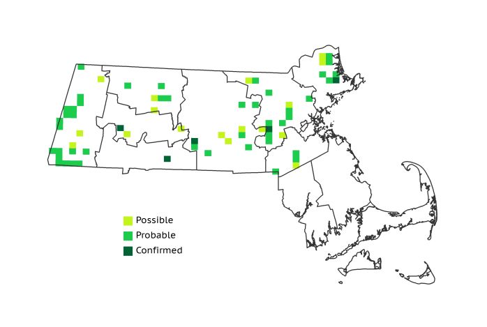
There was no question that the Golden-winged Warbler’s star was waning at the time of Atlas 1, and they were found in only 7% of the blocks surveyed. The Marble Valleys had a remarkably high proportion of occupied blocks (39%), and this accounted for 22% of the species’ statewide range. Neighboring regions in the west hosted small numbers of occupied blocks. The scattered, piecemeal distribution of this species in eastern Massachusetts underscored the pressure the species faced from the disappearance of young forest habitat, as well as from range expansion by the closely related Blue-winged Warbler. Even though certain favored areas in the central and northeastern Coastal Plains still maintained aggregations of breeding activity, nesting Confirmations were few. The species was, as always, absent from southeastern Massachusetts.
Atlas 2 Distribution and Change
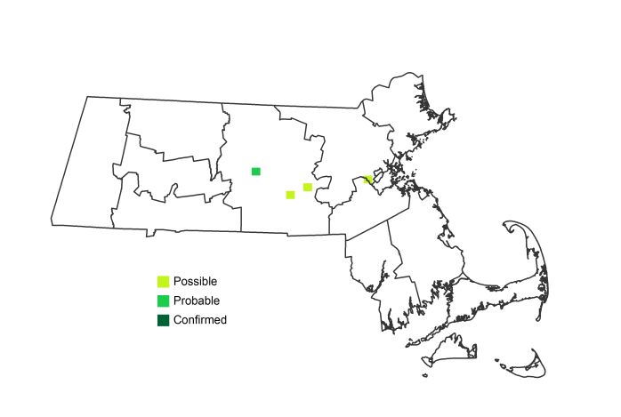
The scale of loss of this species did not go unnoticed during the Atlas interval, and the state listed the Golden-winged Warbler as an Endangered Species. Ready hybridization between this species and the Blue-winged Warbler has no doubt contributed to the decline of the Golden-winged Warbler in Massachusetts, as the “Golden-winged” phenotype has steadily been genetically absorbed by the more numerous Blue-winged Warbler. As a result, individuals clearly identifiable in the field as Golden-winged Warblers became exceptionally rare breeders by the time of Atlas 2, although even hybrids were rarely reported. Eight records scattered around the eastern-central part of the state, none of them Confirmed, provided the only evidence of Golden-winged Warbler breeding activity found during Atlas 2. With no other reports of Confirmed breeding for the Golden-winged Warbler in the past several years, it is fair to say that the species is nearly extirpated as a breeding bird in Massachusetts.
Atlas 1 Map
Atlas 2 Map
Atlas Change Map
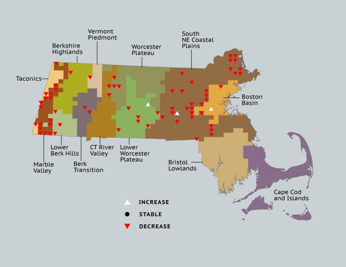
Ecoregion Data
Atlas 1 | Atlas 2 | Change | ||||||
Ecoregion | # Blocks | % Blocks | % of Range | # Blocks | % Blocks | % of Range | Change in # Blocks | Change in % Blocks |
Taconic Mountains | 2 | 12.5 | 3.0 | 0 | 0.0 | 0.0 | -2 | -13.3 |
Marble Valleys/Housatonic Valley | 15 | 38.5 | 22.4 | 0 | 0.0 | 0.0 | -15 | -38.5 |
Berkshire Highlands | 1 | 1.8 | 1.5 | 0 | 0.0 | 0.0 | -1 | -1.9 |
Lower Berkshire Hills | 3 | 10.7 | 4.5 | 0 | 0.0 | 0.0 | -3 | -11.1 |
Vermont Piedmont | 1 | 5.9 | 1.5 | 0 | 0.0 | 0.0 | -1 | -8.3 |
Berkshire Transition | 2 | 5.3 | 3.0 | 0 | 0.0 | 0.0 | -2 | -6.5 |
Connecticut River Valley | 2 | 3.6 | 3.0 | 0 | 0.0 | 0.0 | -2 | -4.2 |
Worcester Plateau | 3 | 3.8 | 4.5 | 0 | 0.0 | 0.0 | -3 | -6.3 |
Lower Worcester Plateau | 6 | 8.1 | 9.0 | 1 | 1.3 | 25.0 | -5 | -9.3 |
S. New England Coastal Plains and Hills | 31 | 11.5 | 46.3 | 2 | 0.7 | 50.0 | -29 | -12.8 |
Boston Basin | 1 | 1.8 | 1.5 | 1 | 1.8 | 25.0 | 0 | 0.0 |
Bristol and Narragansett Lowlands | 0 | 0.0 | 0.0 | 0 | 0.0 | 0.0 | 0 | 0.0 |
Cape Cod and Islands | 0 | 0.0 | 0.0 | 0 | 0.0 | 0.0 | 0 | 0.0 |
Statewide Total | 67 | 6.9 | 100.0 | 4 | 0.4 | 100.0 | -63 | -7.6 |


