Breeding Bird Atlases (BBA)
Find a Bird
Brown Thrasher
Toxostoma rufum
Fairly widespread and strongly declining
Conservation action urgent
State Wildlife Action Plan listed
“Yet, without fail, every spring, since they first fished and hunted here, the brown thrasher has heralded the morning from a birch or alder spray,…” – Henry David Thoreau, A Week on the Concord and Merrimack Rivers
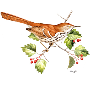
The Brown Thrasher is the least often seen of our breeding Mimids, and it is also the only thrasher species to breed east of the Mississippi. It’s not hard to see why this bird is called a “thrasher” because it forages through the leaf litter, tossing leaves aside with vigorous sweeping motions until it uncovers a tasty morsel. As it happens, the bird’s common name is actually a decayed form of the old name “thrusher,” in reference to the bird’s many thrush-like characteristics. Brown Thrashers seem less willing than catbirds or mockingbirds to move into the suburbs alongside humans, and their numbers appear to be dropping accordingly. The fire-maintained scrub forests of southeastern Massachusetts were historically prime thrasher habitat, but times are changing.
Historic Status
No bird by any other name has ever sung more sweetly than the Brown Thrasher, or Red Mavis, or Ferruginous Mocking-bird, as it has been known through time. It was even called the Planting Bird in some locales, for a song sometimes interpreted as, Plant it, plant it, cover it cover it, I’ll pull it up, I’ll pull it up. As a denizen of dry, shrubby habitats, the species thrived in the days between forest clearing for agriculture and full forest regeneration. Throughout the nineteenth century, observers termed the bird as common and abundant (Peabody 1839), and those adjectives remained accurate into the first half of the twentieth century (Howe & Allen 1901).
Atlas 1 Distribution
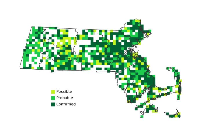
In Atlas 1, occupying 68% of the surveyed blocks, thrashers gravitated toward areas where dry scrubland and other early-successional habitats were available. Particular concentrations of breeding activity were found in the Marble Valleys (82%) and the Connecticut River Valley (91%), though Brown Thrashers were present throughout western Massachusetts. They took advantage of overgrown clearings and a growing number of corridors cut for high-tension lines across the Worcester and Lower Worcester Plateaus, but their distribution was most heavily concentrated in the eastern part of the state. Old farms, wooded edges, and especially coastal scrub areas hosted thrashers aplenty in the Coastal Plains and the Boston Basin. Block occupancy surpassed 70% in both regions. The eastern Bristol/Narragansett Lowlands and the base of Cape Cod were also hot spots for Brown Thrashers through Atlas 1.
Atlas 2 Distribution and Change
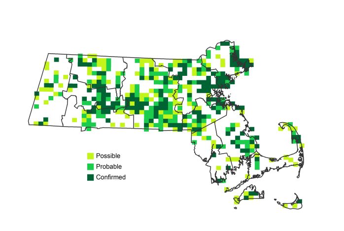
Sadly, in Atlas 2 Brown Thrashers found themselves on the receiving end of a good thrashing as multiple forces conspired to drive them into decline, and overall they were found in only 42% of the Atlas 2 blocks surveyed. Every region in the state reported fewer occupied blocks for this species than in the first Atlas, save the Vermont Piedmont, which overall managed to come in with a tie. Using the effort-controlled data, they were lost from 32% of the state. The species disappeared entirely from the Lower Berkshire Hills, and had particularly steep declines in the Marble Valleys, Berkshire Highlands, and Berkshire Transition. The central part of the state fared little better, and the Coastal Plains lost thrashers in 28% of the blocks. The greatest losses came from the Bristol/Narragansett Lowlands and the Cape and Islands. While Brown Thrashers were formerly widespread in both regions, they disappeared from more than 45 blocks in each region overall during the inter-Atlas period.
Atlas 1 Map
Atlas 2 Map
Atlas Change Map
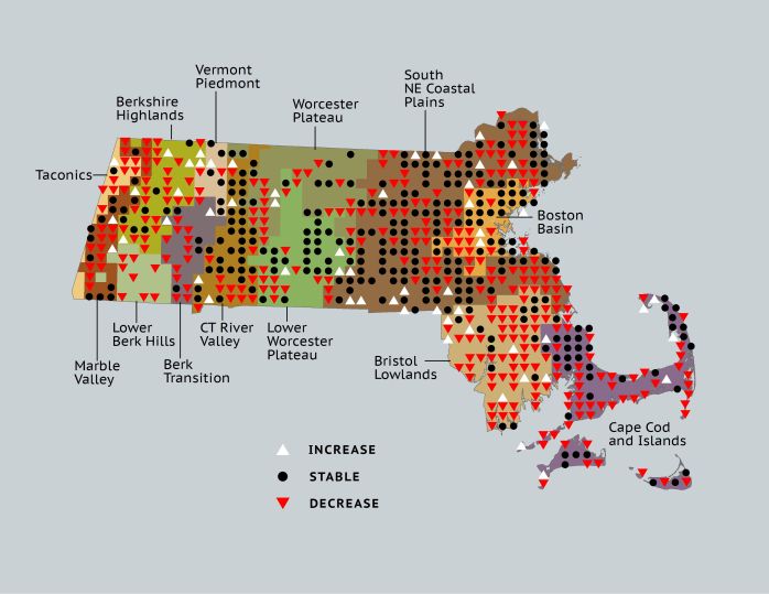
Ecoregion Data
Atlas 1 | Atlas 2 | Change | ||||||
Ecoregion | # Blocks | % Blocks | % of Range | # Blocks | % Blocks | % of Range | Change in # Blocks | Change in % Blocks |
Taconic Mountains | 9 | 56.3 | 1.4 | 2 | 8.0 | 0.5 | -7 | -46.7 |
Marble Valleys/Housatonic Valley | 32 | 82.1 | 4.8 | 16 | 41.0 | 3.7 | -16 | -41.0 |
Berkshire Highlands | 30 | 54.5 | 4.5 | 15 | 27.3 | 3.5 | -16 | -30.2 |
Lower Berkshire Hills | 8 | 28.6 | 1.2 | 0 | 0.0 | 0.0 | -8 | -29.6 |
Vermont Piedmont | 10 | 58.8 | 1.5 | 10 | 58.8 | 2.3 | -2 | -16.7 |
Berkshire Transition | 20 | 52.6 | 3.0 | 9 | 22.5 | 2.1 | -12 | -38.7 |
Connecticut River Valley | 51 | 91.1 | 7.7 | 43 | 66.2 | 10.0 | -8 | -16.7 |
Worcester Plateau | 40 | 51.3 | 6.1 | 31 | 35.2 | 7.2 | -15 | -31.3 |
Lower Worcester Plateau | 47 | 63.5 | 7.1 | 39 | 48.8 | 9.1 | -13 | -24.1 |
S. New England Coastal Plains and Hills | 209 | 77.4 | 31.6 | 163 | 57.6 | 37.9 | -64 | -28.3 |
Boston Basin | 42 | 75.0 | 6.4 | 30 | 53.6 | 7.0 | -13 | -23.6 |
Bristol and Narragansett Lowlands | 73 | 68.9 | 11.0 | 26 | 22.8 | 6.0 | -47 | -46.5 |
Cape Cod and Islands | 90 | 66.2 | 13.6 | 46 | 31.9 | 10.7 | -44 | -36.7 |
Statewide Total | 661 | 68.2 | 100.0 | 430 | 41.5 | 100.0 | -265 | -32.0 |
Notes
The Brown Thrasher shows significant decreasing Breeding Bird Survey trends in Massachusetts, in the New England/Mid-Atlantic Region, and in the Eastern US overall.


