Breeding Bird Atlases (BBA)
Find a Bird
Wild Turkey
Meleagris gallopavo
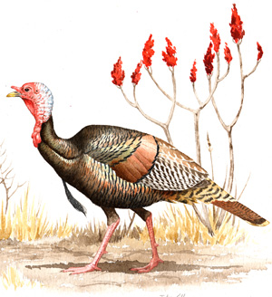
Very widespread and strongly increasing
“He is besides, though a little vain & silly, a Bird of Courage, and would not hesitate to attack a Grenadier of the British Guards who should presume to invade his Farm Yard with a red Coat on.” – Benjamin Franklin
While turkeys may have found their way onto our dinner tables since the days of the First Thanksgiving, Wild Turkeys were nonetheless absent from Massachusetts for over 100 years. The good news is that no repatronization program in the history of the Commonwealth has been as wildly successful as that of the Wild Turkey. These birds are primarily denizens of a patchwork landscape. Farm fields for displaying, bordered by woodlots and copses of trees, are ideal, although mature suburban neighborhoods seem to satisfy them just as well.
Historic Status
Deliciousness killed the Wild Turkey in Massachusetts in the nineteenth century. Early reporters around Plymouth presumably salivated as they noted the birds to be “farre greater than our English Turkies, and exceeding fat, sweet and fleshy...” (Bradford 1620-1647). Turkeys made their way onto the first Thanksgiving table but ironically would be gone from the state entirely by the time the holiday was revived by President Abraham Lincoln in the 1860s. The Connecticut River Valley was the last holdout for the turkey in Massachusetts, with a section of the pathway over Mount Holyoke being known to hunters as “Turkey Pass” (Allen 1919). The last recorded Wild Turkey in Massachusetts was seen, and probably shot, on Mount Tom in 1851. By the time of the publication of the third volume of Forbush's Birds of Massachusetts and Other New England States in 1929, turkeys were listed at the end of the book along with the Great Auk and Labrador Duck as “New England Birds Exterminated or Extirpated in Recent Times.” Nine restoration attempts between 1911 and 1967 yielded no results, but by the early 1970s, after several more releases, turkeys began to once again breed in Massachusetts (Petersen & Meservey 2003).
Atlas 1 Distribution
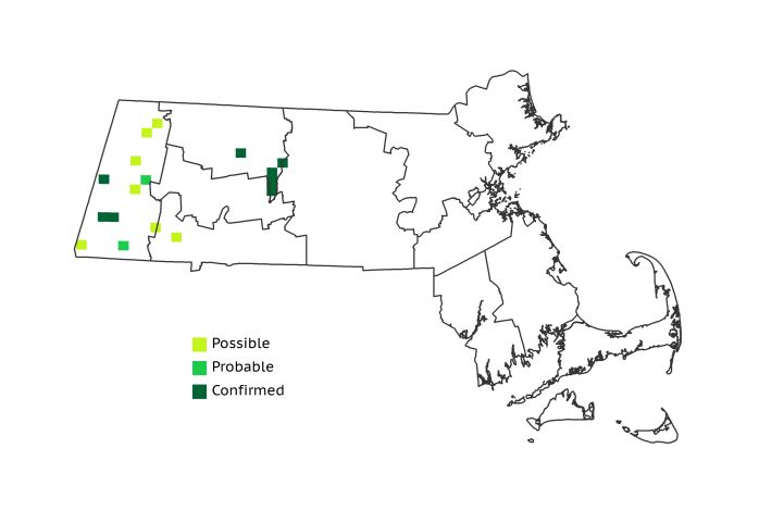
During Atlas 1 released Wild Turkeys were just beginning to reclaim the species’ former Massachusetts territory. The entire eastern half of the state was devoid of turkeys, and the easternmost breeders were Confirmed only in the western Worcester Plateau. Breeding turkeys proved to be cagey and secretive quarry for the Atlas crew, with only a scattering of Possible and Probable blocks throughout the Berkshire Highlands and Taconic Mountains. The wooded lowlands of the Berkshire Hills and Marble Valleys yielded only 3 additional Confirmed blocks, and that was the extent of breeding Wild Turkey activity at the time.
Atlas 2 Distribution and Change
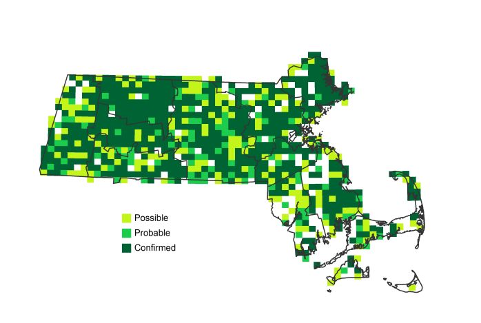
As any Massachusetts resident attempting to safely drive on the state’s side roads will tell you, Wild Turkeys have definitely returned. Not only that, they have practically taken over, reaching from the extreme western part of the state to the end of the Elizabeth Island chain, where a mother and her brood were seen on tiny Cuttyhunk Island. The species’ adaptability has shown almost no habitat limitations, since daily interactions between humans and turkeys are becoming commonplace practically throughout the state. In all, the reestablishment of the Wild Turkey and its rampant range recovery in less than half a century should go down as the greatest returning native avian species success story in Massachusetts history.
Atlas 1 Map
Atlas 2 Map
Atlas Change Map
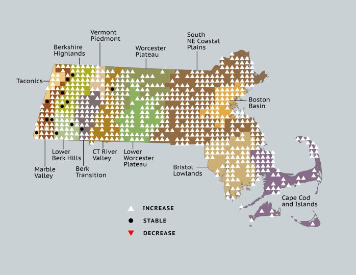
Ecoregion Data
Atlas 1 | Atlas 2 | Change | ||||||
Ecoregion | # Blocks | % Blocks | % of Range | # Blocks | % Blocks | % of Range | Change in # Blocks | Change in % Blocks |
Taconic Mountains | 1 | 6.3 | 5.9 | 15 | 60.0 | 1.8 | 9 | 60.0 |
Marble Valleys/Housatonic Valley | 4 | 10.3 | 23.5 | 35 | 89.7 | 4.3 | 31 | 79.5 |
Berkshire Highlands | 3 | 5.5 | 17.6 | 54 | 98.2 | 6.6 | 49 | 92.5 |
Lower Berkshire Hills | 3 | 10.7 | 17.6 | 27 | 87.1 | 3.3 | 22 | 81.5 |
Vermont Piedmont | 0 | 0.0 | 0.0 | 17 | 100.0 | 2.1 | 12 | 100.0 |
Berkshire Transition | 1 | 2.6 | 5.9 | 38 | 95.0 | 4.6 | 30 | 96.8 |
Connecticut River Valley | 1 | 1.8 | 5.9 | 57 | 87.7 | 7.0 | 43 | 89.6 |
Worcester Plateau | 3 | 3.8 | 17.6 | 85 | 96.6 | 10.4 | 47 | 97.9 |
Lower Worcester Plateau | 1 | 1.4 | 5.9 | 71 | 88.8 | 8.7 | 49 | 90.7 |
S. New England Coastal Plains and Hills | 0 | 0.0 | 0.0 | 242 | 85.5 | 29.5 | 197 | 87.2 |
Boston Basin | 0 | 0.0 | 0.0 | 40 | 71.4 | 4.9 | 39 | 70.9 |
Bristol and Narragansett Lowlands | 0 | 0.0 | 0.0 | 71 | 62.3 | 8.7 | 67 | 66.3 |
Cape Cod and Islands | 0 | 0.0 | 0.0 | 67 | 46.5 | 8.2 | 57 | 47.5 |
Statewide Total | 17 | 1.8 | 100.0 | 819 | 79.0 | 100.0 | 652 | 78.6 |


