Find a Bird
American Kestrel
Falco sparverius

Somewhat local and strongly declining
Conservation action urgent
State Wildlife Action Plan listed

“An eagle for an Emperor….a kestrel for a knave.” – The Book of Saint Albans
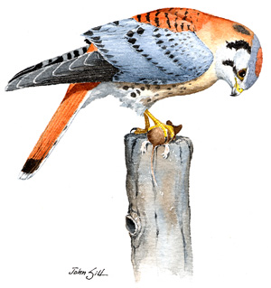
A few decades ago, American Kestrels could be seen hovering and dropping on their prey in just about every open field of sufficient size in the Commonwealth of Massachusetts. These agile and colorful little raptors have long been a favorite of casual birders and experienced ornithologists alike. These days, however, our smallest falcon is becoming harder and harder to find. Loss of grassland habitat certainly hasn’t helped American Kestrels, but fortunately they remain widespread enough that recovery is still a possibility.
Historic Status
Birders in Cambridge, Massachusetts, were surprised to look up one day in 1877 and see an American Kestrel sitting on a nest (Brewster 1906). Eleven years later, the instance occurred again, and, from that point onward, the kestrel would become a dedicated Massachusetts resident. The species took well to urban neighborhoods by the 1920s, watching the action at Boston's Public Gardens and nesting by Mattapan’s Walk Hill Street, on a factory in Holyoke, on a tannery in Peabody, and in other equally populated places (Forbush 1927). But it was the farmland that attracted them to Massachusetts – the wide-open foraging areas on which they could find sustenance. The move away from agriculture and the gradual reforestation of the state in the latter half of the nineteenth century signaled tough times ahead for the species.
Atlas 1 Distribution
American Kestrels could be found breeding from the Berkshires to Nantucket during Atlas 1. An impressive 85% of blocks in the Marble Valleys had breeding kestrels, and even the high Taconic Mountains produced more than a dozen occupied blocks. The open farmland of the Connecticut River Valley is visible on the map as a band of occupied blocks stretching the full height of the state, with scattered blocks adjacent in the Vermont Piedmont and Berkshire Transition zones. It is not surprising, then, that kestrels were found in 59% of the Connecticut River Valley region. In the more heavily forested Worcester Plateau regions, kestrels were notably less widespread, although there were still about 40 occupied blocks (mostly in the Lower Worcester Plateau). The eastern half of the state had kestrels aplenty; the Cape and Islands, the Bristol/Narragansett Lowlands, and the Coastal Plains all had greater than 50% block occupancy, and the developed Boston Basin had evidence of breeding kestrels in over 70% of its blocks.
Atlas 2 Distribution and Change
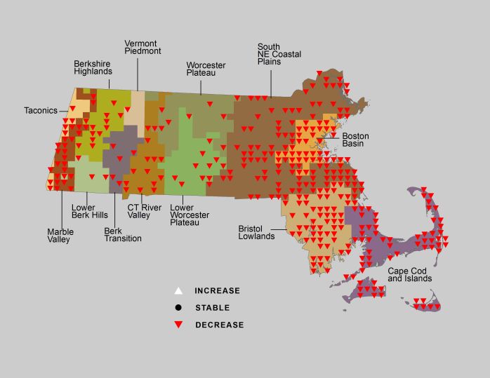
Atlas 2 found American Kestrel to be a much-declined species across the state. The only region in which American Kestrels did not decline in overall occupancy was the Vermont Piedmont, which reported new kestrels in 33% of blocks (4) and lost kestrels in only 1. Other than this instance, the question statewide was not whether the American Kestrel’s distribution was shrinking, but rather by how much. In some western regions, such as the Connecticut River Valley and the Lower Berkshire Hills, the decline only slightly outpaced the rate of new growth. In more eastern ecoregions, the combined pressures of forest regeneration and suburban development resulted in huge drops in block occupancy. American Kestrels now occupy only a fraction of their previous breeding distribution in the Coastal Plains, Boston Basin, and Bristol/Narragansett Lowlands. On Cape Cod and the Islands, the species teeters perilously close to regional extirpation as a breeding species.
Atlas Change Map

Ecoregion Data
Atlas 1 | Atlas 2 | Change | ||||||
Ecoregion | # Blocks | % Blocks | % of Range | # Blocks | % Blocks | % of Range | Change in # Blocks | Change in % Blocks |
Taconic Mountains | 13 | 81.3 | 2.6 | 7 | 28.0 | 3.3 | -6 | -40.0 |
Marble Valleys/Housatonic Valley | 33 | 84.6 | 6.6 | 10 | 25.6 | 4.7 | -23 | -59.0 |
Berkshire Highlands | 23 | 41.8 | 4.6 | 18 | 32.7 | 8.4 | -6 | -11.3 |
Lower Berkshire Hills | 4 | 14.3 | 0.8 | 3 | 9.7 | 1.4 | -1 | -3.7 |
Vermont Piedmont | 7 | 41.2 | 1.4 | 14 | 82.4 | 6.5 | 3 | 25.0 |
Berkshire Transition | 9 | 23.7 | 1.8 | 7 | 17.5 | 3.3 | -2 | -6.5 |
Connecticut River Valley | 33 | 58.9 | 6.6 | 29 | 44.6 | 13.5 | -5 | -10.4 |
Worcester Plateau | 14 | 17.9 | 2.8 | 13 | 14.8 | 6.0 | -5 | -10.4 |
Lower Worcester Plateau | 25 | 33.8 | 5.0 | 18 | 22.5 | 8.4 | -7 | -13.0 |
S. New England Coastal Plains and Hills | 148 | 54.8 | 29.7 | 58 | 20.5 | 27.0 | -87 | -38.5 |
Boston Basin | 40 | 71.4 | 8.0 | 11 | 19.6 | 5.1 | -30 | -54.5 |
Bristol and Narragansett Lowlands | 70 | 66.0 | 14.1 | 14 | 12.3 | 6.5 | -55 | -54.5 |
Cape Cod and Islands | 79 | 58.1 | 15.9 | 13 | 9.0 | 6.0 | -65 | -54.2 |
Statewide Total | 498 | 51.4 | 100.0 | 215 | 20.7 | 100.0 | -289 | -34.9 |
Notes
American Kestrels show significant decreasing Breeding Bird Survey trends in Massachusetts, in the New England/Mid-Atlantic Region, and in the Eastern US overall. Although American Kestrel distribution is shrinking statewide, an island of stability in southeastern Massachusetts has formed around a number of kestrels using nest boxes erected for them at commercial cranberry bogs. To protect this species from potential illegal taking we do not disclose the location of occupied blocks, and the map only registers blocks where the species declined from Atlas 1 to Atlas 2.


